- AUTOMOTIVE
- BOATING
-
DIVING
- Bags
- BCDS
- Belts
- Chargers & Batteries
- Cylinders
- Diving Sets
- DPV Scooters
- Dry Boxes
- Fins
- General Accessories
- Instruments
- Knives
- Lifting Bag
- Masks
- Neoprene Accessories
- Regulators & Octopus
- Sets and Combo
- Signaling Buoys
- Snorkels
- Speargun Accessories
- Spearguns
- Suits
- Torches
- Underwater Cameras & Parts
- Underwater Communication Systems
- Watches
- ENGINE
- FISHING
- GARMIN
- INDUSTRIALS
- SOLAR ENERGY
- SPORTS
- SPECIAL OFFERS
- CONTACT US


GPSMAP H1 - Premium Handheld GPS - 010-02920-01 - Garmin
- Brand: Garmin
- Product Code: 010-02920-01
- Availability: In Stock
- $693.69
- Ex Tax: $693.69
GPSMAP H1 - Premium Handheld GPS - 010-02920-01 - Garmin :


IN THE BOX:
- GPSMAP® H1
- Loop Carabiner
- USB cable
- Documentation
| InReach Features | |
| InReach Remote Compatible | Yes |
| Security information | |
| SECURITY UPDATES UNTIL AT LEAST (YYYY-MM-DD) | 2027-09-03 |
| Physical & Performance | |
| Glonass | Yes |
| GENERAL | |
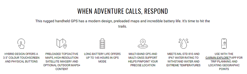
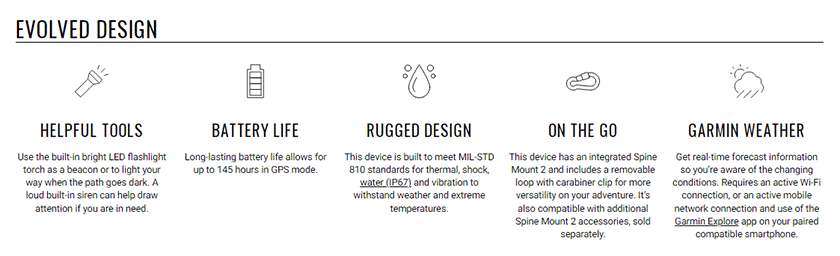
| Battery life | All Satellite Systems + Multi-Band: Up to 145 hours* Expedition Mode: up to 840 hours |
| Battery type | Rechargeable, internal lithium-ion |
| DIMENSION | 6.7 cm x 17.9 cm x 3.3 cm (2.6″ x 7″ x 1.3″) |
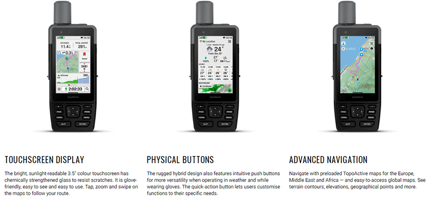
| Display resolution | 282 x 470 pixels |
| Display size | 4.7 x 7.7 cm (1.9″W x 3″H), 8.9 cm (3.5″ diagonal) |
| Display type | Transflective color TFT |
| Interface | USB-C |
| Memory/history | 64 GB (user space varies based on included mapping) |
| MIL-STD-810 | Yes (thermal, shock, water); bare unit only |
| Water rating | IP67 |
| Weight , | 276 g (9.7 oz) |
| Sensors | |
| Barometric altimeter | Yes |
| BEIDOU | Yes |
| Compass | Yes |
| Galileo | Yes |
| GPS | Yes |
| GPS Compass | Yes, (WHILE MOVING) |
| HIGH-SENSITIVITY RECEIVER | Yes |
| IRNSS | Yes |
| MULTI-BAND FREQUENCY | Yes |
| QZSS | Yes |
| Daily Smart Features | |
| ACTIVE WEATHER | Yes |
| Compatible with Garmin Connect™ Mobile | Yes |
| Connect IQ™ | Yes, (DOWNLOADABLE WATCH FACES, DATA FIELDS, WIDGETS, AND APPS) |
| SMART NOTIFICATIONS ON HANDHELD | Yes |
| VIRB® Camera Remote | Yes |
| Maps & Memory | |
| Ability to add maps | Yes |
| ACTIVITIES | Yes |
| Basemap | Yes |
| COURSES | 250, 200-course points per course |
| DISPLAYS NATIONAL, STATE/ LOCAL PARKS, FORESTS, WILDERNESS AREAS | Yes, |
| INCLUDES DETAILED HYDROGRAPHIC FEATURES | Yes, (COASTLINES, LAKE/RIVER SHORELINES, WETLANDS, AND PERENNIAL AND SEASONAL STREAMS) |
| INCLUDES SEARCHABLE POINTS OF INTERESTS | Yes, (PARKS, CAMPGROUNDS, SCENIC LOOKOUTS AND PICNIC SITES) |
| MAP SEGMENTS | 15,000 |
| NAVIGATION ROUTES | 250, 250 points per route; 50 points auto routing |
| NAVIGATION TRACK LOG | 20,000 points, 250 saved gpx tracks, 300 saved fit activities |
| Preloaded maps | Yes (TopoActive Europe; routable) |
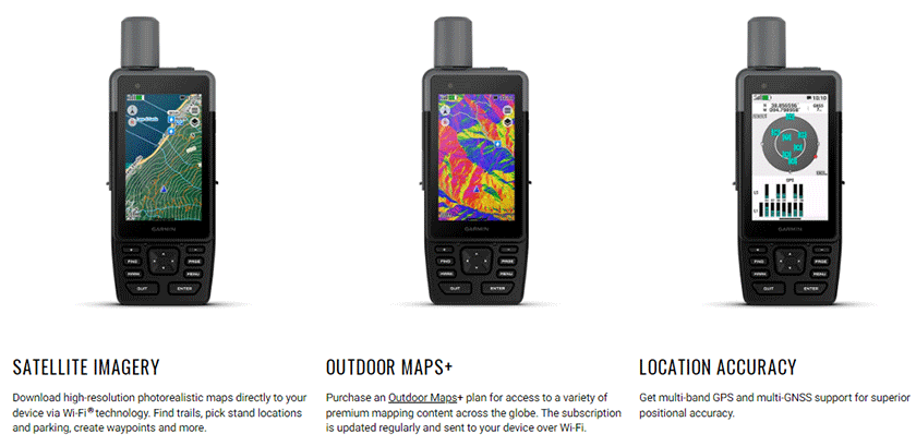
| SATELLITE IMAGERY | Yes (direct to device) |
| Storage and Power Capacity | Yes (1 TB max microSD card) |
| Tracks | 250 |
| Waypoints/favourites/locations | 10,000 |
| Safety and tracking features | |
| LiveTrack | Yes |
| Connections | |
| CONNECTIONS WIRELESS CONNECTIVITY | Yes (Wi-Fi®, Bluetooth®, ANT+®) |
| Outdoor Recreation Features | |
| Area calculation | Yes |
| Hunt/fish calendar | Yes |
| LED BEACON FLASHLIGHT | Yes |
| Point-to-point navigation | Yes |
| Sun and moon information | Yes |
| TracBack® | Yes |
| XERO™ Locations | Yes |
| OUTDOOR APPLICATIONS | |
| COMPATIBLE WITH GARMIN EXPLORE™ APP | Yes |
| Garmin Explore Website Compatible | Yes |
| Outdoor Features | |
| Automatic routing (turn by turn routing on roads) | Yes, FOR OUTDOOR ACTIVITIES |
| Custom maps compatible | Yes (500 custom map tiles) |
| Geocaching-friendly | Yes (Geocache Live) |
| Picture viewer | Yes |


Tags: GPS, handheld gps, Navigation, Satellite, Communicator,
Azzi Sport Copyright @2023
Developed by Software Senior
